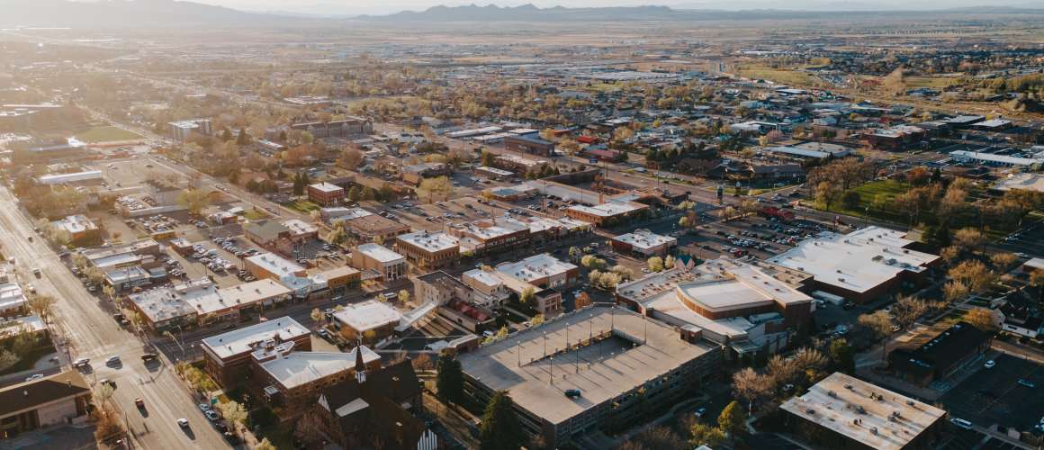
Communities

Add To Bucket List

Communities

You can find even more fun and adventure in the cities around Cedar City. As you explore the parks of Southern Utah, visit these communities to discover their rich history, culture and folklore. You can enjoy breathtaking views on a drive through scenic byways, go sightseeing on horseback, experience the awe-inspiring Parowan Gap Petroglyphs and even tour a ghost town. See what else you can find when you let wonder be your guide.

Discover a New Circle

What’s not to love about Brian Head? Here’s a laid back village where people and nature happily coexist. Located at the 9,700 foot elevation, Brian Head is the highest town in Utah, which means summers are darn pleasant and winters become a snowy wonderland. Mother Nature blessed the town with incredible mountain terrain for nearly every type of outdoor activity and surrounded it with Utah’s famous red rock scenery. Right outside your hotel, condo, even yurt, you can go mountain biking, hiking, skiing and snowmobiling — the options are endless and friendly locals invite you to enjoy them all. Mountains of memories are made in Brian Head.

  • Brian Head History

    The story behind Brian Head begins with the most basic element of folklore: the naming of the place. No one really knows the origin of Brian Head’s unique name, but the stories of the names are often as interesting as the people that tell them.


    Brian Head was originally known as Monument Peak and was used by early surveyors and expedition leaders as a point of reference. The name changed in the early 1900s. Exactly why the name changed, however, is subject to conjecture.


    One story claims that famous explorer John Wesley Powell saw the peak above all the other mountains and named it after an official in the Geological Survey Office by the name of Bryan.


    Another story claims that residents of neighboring Parowan changed the name in 1890 to Bryan Head in honor of an American politician named William Jennings Bryan. Still, another claims that the wife of a United States government official visited the area, didn’t like the name of Monument Peak, and wrote letters to prominent government officials to change the name to Bryan Head (the spelling has obviously since been to “Brian” Head.)


    As the Brian Head area grew, so did industry. Soon the area was teeming with farming, grazing, and logging. There was even a small section of town known as Little Ireland that became famous for its butter and cheese.


    Early day in Brian Head included a hotel, restaurant, and dance hall that was operated by Minnie Adams Burton. “Minnie’s Mansion” became the gathering place for people from all around. On the 24th of July, an annual celebration commenced at Minnie’s that brought sheep and cattle herders from miles around for huge breakfasts, horse racing, potato sack races, fireworks, and dancing.


    In more recent times, local resident Burt Nichols saw something in the beautiful slopes surrounding the town, and in 1964, he opened the Brian Head Resort with one chairlift, a T-bar, and a warming house. The town of Brian Head incorporated in 1975. In 1990, Brian Head Resort was able to expand its season when they added snowmaking technology and terrain parks for snowboarding. That same year, Brian Head became a premier mountain bike destination utilizing the over 200 miles of existing livestock trails that lend to superb mountain biking downhill. In late 2007, the resort completed an expansion effort that increased their skiable terrain to over 650 acres including a new snowmaking system and an interconnecting bridge.

  • Skiing & Boarding

    Brian Head Resort receives over 360 inches of famous Utah powder every year. The resort features Utah’s highest base elevation of 9,600 ft. with a lift-served vertical drop of 1,320 ft. from Brian Head Peak. Brian Head has over 650 acres, with eight chairlifts, 71 runs and three terrain parks for all ability levels.

  • Tubing

    With a tubing hill located at Giant Steps, this is a winter activity almost anyone can enjoy. A surface lift whisks you to the top of the hills 600 ft. long courses, and you’ll be swooshing down the mountain and then back at the top in no time at all. For quality assurance and to secure a tubing session, please call (435) 677-2035 for reservations, or check www.brianhead.com.

  • Snowmobiling

    Snowmobile tours are available in Brian Head to the Cedar Mountain Snowmobile Complex, considered one of the most scenic snowmobiling areas in the west. The complex has over 160 miles of pristine trails and wide open play areas. Trailheads are located at Brian Head and Cedar Breaks. Check the Guides and Outfitters for tours.

  • Mountain Biking

    Experience incredible mountain biking at the Brian Head Mountain Bike Park and Activity Center, voted “one of the best, unique and most unusual mountain bike vacation resorts” by Mountain Bike Action magazine. Bikers can access over 200 miles of single and double track trails, with a wide array of options in trail length and technical ability.

  • Scenic Chairlift Rides

    In the summer, the mountain bike chairlift at Brian Head Ski Resort (chair #2) is also available to hikers and sightseers in search of Utah’s famous red-rock vistas. Bring a jacket — the view is fabulous but it’s definitely cool at 11,000 feet. Open on weekends, generally from early July through mid-September. Go to www.brianhead.com for chairlift schedule and cost.

  • Off Highway Vehicle (OHV)

    Dirt roads and trails left from the pioneer days ribbon through southern Utah’s landscape, making for some of the best off-highway riding in the state. There are over 400 miles of designated trails in the high mountain passes of the Dixie National Forest area of the Markagunt Plateau. OHV rentals and tours are available with local outfitters. Check with local visitor centers, the Dixie National Forest, (1789 N. Wedgewood Dr, Cedar City, (435) 865-3700), and the Bureau of Land Management, (176 DL Sargent Dr, Cedar City, (435) 865-3000 for designated trails and maps.

  • Kids' Stuff

    In the summer and Fall, the Bristlecone Pond is a fun place in town for the family to hang out, catch some fish, or bring your kayak.


    Don’t forget Gaint Steps on the weekends to entertain your inner adrenaline junkie with mini zip-line, chairlift rides, disc golf, and bungee trampoline. If you are up for a physical challenge, spend the day at the climbing wall and then ride your cares away at the alpine tubing hill.

  • Local Fave

    Brian Head offers a free town shuttle during the ski season with front door service to the Resort base lodges.

  • Plan Your Trip

    Population

    83


    Elevation

    9,700 feet


    Distance from Cedar City

    32 miles


    Brian Head Town Visitor Center

    56 N. Hwy 143
    Brian Head, UT 84719
    (435) 677-2029

Cedar City is a surprisingly cool mountain town that just happens to have world-class cultural attractions in astonishing proximity to southwest Utah’s famous Mighty Five© National Parks. Cedar City is also known as “Festival City, USA,” with a plethora of events taking place year-round such as free music festivals, downtown parades, and touring bike races.


Though free from crushing traffic and frantic city pacing, Cedar City doesn’t skip on amenities. Historic Downtown is quaint with local shops and an impressive menu of “urban-esque” cuisine and Southern Utah’s only winery. Southern Utah University keeps things interesting with Division I athletics, guest lectures, and concerts, AND they just happen to be the “Most Outdoorsy University” in the nation. Paved trails weave the perimeter of town connecting you to the great outdoors and miles of recreational paths for mountain biking, hiking, and OHV riding.

  • Cedar City History

    When iron deposits were found in Southern Utah, Mormon leader Brigham Young called for volunteers to colonize the Iron Mission Area. A site near Coal Creek was selected in November 1851 for the Iron Works. Originally called Little Muddy, then Coal Creek, Cedar City was named for the “cedar” trees in the area, though these trees are actually juniper trees. Ten months after site selection, the new colony completed a small blast furnace and began to operate the iron foundry. It was the first iron to be manufactured west of Missouri. Because of problems with the furnace, flood and hostility between settlers and Native Americans, the foundry closed in 1858. Unlike many small mining towns of that era, Cedar City continued to grow and prosper. Residents turned to farming and agriculture for economic well-being. Mining efforts began again to help provide much needed ore during WWII and continued until the 1980s.

  • Determination for Education

    In 1897, the people of Cedar City learned that the Utah Legislature had authorized a school for higher learning in Southern Utah. The community labored to construct the Ward Hall, however, after being in session only two months, the attorney general stated that the school had to have its own building on land deeded to the state. He said if the building was not erected by the following September, the school would be lost. At that point, winter had set in and building materials were nonexistent. The residents of Cedar City were unencumbered as they planned to make the trek up the mountain to secure the necessary logs for the building.


    For days the team of wagons waded through one of the worst mountain snowstorms ever to hit Southern Utah. The snow was often shoulder-deep as the men pushed their way up the mountain toward the lumber mills. They slept in holes scraped out of the snow. After reaching the sawmill and gathering the necessary lumber, the men were discouraged with the realization that they now had to turn back. The wagons that could not make it were abandoned. Tired and frozen, the party felt they could go no further. It was then that an old sorrel horse proved invaluable. Placed out at the front of the party, the horse would walk steadily into the drifts, pushing against the snow, throwing himself into the drifts again and again until they gave way. When he paused to rest, he sat on his haunches the way a dog would. Then onward he would push. “Old Sorrel” was credited with being the savior of the expedition. In the fall of 1898, the building was complete. The people of Cedar City had persevered and finished the building known today as Old Main. A statue of “Old Sorrel” also stands as a monument to the dedication of a people and their commitment to education.


    In 1913, the college became a branch of Utah State Agricultural College of Logan. In 1968, the legislature transformed it into a 4-year college of liberal arts and science with elementary and secondary teacher education programs. On January 1, 1991, it attained university status. In addition to being an educational haven, Southern Utah University is also the home of the world-renowned Utah Shakespeare Festival and The Utah Summer Games. Both of these events bring increasing numbers of tourists to this thriving community every year.

  • The Railroad is Here!

    The Union Pacific Railroad Company reached Cedar City in 1923. This contributed greatly to Cedar City’s growth in mining and agriculture, providing an outlet for the products of the iron mines as well as produce. The railroad exposed Utah’s National Parks to the world of tourism and Cedar City was dubbed “the gateway to the parks.” Though the Depot was closed in 1959, the railroad still comes through Cedar City and transports products in and out of the community.

  • Utah Shakespeare Festival

    Enjoy Award-winning festival in three stunning theaters: the outdoor Engelstad Theatre, which is a replica of Shakespeare’s Globe Theatre, the indoor Randall L. Jones Theatre, a stunning modern facility featuring contemporary works, and indoor Anes Studio Theater, an intimate 200-seat performance space. Enjoy matinee and evening performances, backstage tours and a free greenshow during the summer season.  Summer season: late June through Labor Day. and Fall season: midSeptember through midOctober.  Located at 351 W University Blvd.  Box Office is 1(800) PLAYTIX. www.bard.org.

  • Southern Utah Museum of Art (SUMA)

    As part of the Beverley Taylor Sorenson Center for the Arts, this state-of-the-art museum is home to 5,300 square feet of exhibition space composed of several individual galleries. SUMA hosts FREE exhibitions from around the world, as well as a special collection of work by Utah artist Jim Jones, and features rotating exhibits from the permanent collections. SUMA also regularly exhibits works of Southern Utah University’s Art and Design students and faculty as well as provides a venue for displaying regional artists and juried shows. Located at 300 W. University Blvd./Center St. (435) 586-5432 www.suu.edu/suma.

  • Frontier Homestead State Park

    Experience time travel through the park’s massive collection of horse-drawn vehicles. You can imagine yourself as a stagecoach driver or a pioneer crossing the plains in a covered wagon. Experience life on the frontier with interactive displays and exhibits dedicated to pioneer life. Cost is $4 per person. Open all year, 9 a.m. to 5 p.m. Monday – Saturday with extended hours in the summer. Located at 635 N. Main, Cedar City. (435) 586-9290 www.frontierhomestead.org.

  • Cedar City Historic Downtown Shopping District

    The historic downtown has quaint shops, local restaurants, coffee houses, an old time soda fountain, antique stores, and regional arts & crafts shops. Historical buildings in the district include the Old Post Office, the Rock Church and the Union Pacific Railroad Depot. Open all year with most shops open Monday through Saturday. The shopping district includes the area of Main Street from 200 North to University Blvd.

  • Veterans Memorial Park

    Features stunning large scale memorials, statues, monuments and walking trails built in honor of veterans of World War I, World War II, Korea, Vietnam, Afghanistan and Iraq.  The park is open all year during daylight hours only, weather permitting. Located next to the Coal Creek at 200 N. (Freedom Blvd) and 200 East.

  • Kids' Stuff

    Park Discovery

    Park Discovery is a fun, educational place where kids of all ages can learn and play. Concepts from over 4,000 local kids were integrated into the design concept of the park. Along with educational play elements, there’s an outdoor classroom, stage area, a separate play area for toddlers, handicap accessible ramps and swings, and a ¾ paved walking trail that surrounds the park. Directions: head west on Cross Hollow Road (I-15 Exit #57) to Royal Hunte Dr., turn right, and go all the way to the top of the hill to the parking area next to the Iron County School District building. Open daily-, yearround, weather permitting, from sunup to sundown. (435) 865-9223.

  • Local Fave

    Two yearround farmers markets feature crafts and tasty locally grown produce, baked goods, cheeses, and crafts every Saturday. 


    The Downtown Year Round Farmers Market is located behind I/G Winery at Stratford Court at 45 W University Blvd/Center St, Cedar City.


    Cedar Saturday Market is located in the IFA parking lot (summer) and inside (winter) 905 S Main St, Cedar City.

  • Plan Your Trip

    Cedar City, Utah


    Population

    28,867


    Elevation

    5,400 feet


    Cedar City Visitor Center

    581 N. Main St
    Cedar City, UT 84721
    (435) 586-5124
    www.visitcedarcity.com


    Cedar City Office

    10 N. Main St
    Cedar City, UT 84720
    (435) 586-2950
    www.cedarcity.org


    Cedar City Chamber of Commerce

    510 W. 800 South
    Cedar City, UT 84720
    (435) 586-4484
    www.cedarcitychamber.org

Enoch is the second largest city in Iron County. Located slightly north of Cedar City, Enoch is a widespread rural community that thrives with agriculture. In the early 2000s, the community saw a huge increase in population as well as demands. The residents were more eager than ever to expand local businesses, churches and neighborhoods to accommodate the basic services. Today, nearly 6,000 people reside in Enoch and it is expected to continue growing.


Not only is Enoch teeming with agriculture, but it is rich in history, too. The area was first stumbled upon in the mid 1800s during one of the most prevalent times in history: the Old Spanish Trail. Being one of the major stopping points for trading and riches, the area was later revisited in 1851 where it was formerly named Johnson’s Ranch. Joel J. Johnson was the first settler of the area but only stayed temporarily due to Indian troubles. Several years later the area was inhabited once again with travelers and reestablished as Johnson’s Fort. The rural area grew for the first time when John Pidding Jones, his family and others migrated to Johnson’s Fort. In 1956, the then former Johnson’s Fort was officially settled as Enoch after the Mormon United Order. Small communities began to take root and the agriculture system escalated with growing demands that still stand to this day.

  • Off Highway Vehicle (OHV)

    Head out toward Three Peaks Recreational Area and cruise over volcanic rock formations and rolling hills. Several times a year 4 x 4 rock crawling competitions are held.

  • Mountain Biking

    Race down one of the many biking trails over large rock formations and through the challenging desert terrain in the Three Peaks Recreational Area.

  • Horseback Riding

    Enjoy a relaxing day of horseback riding and siteseeing as you explore the magnificent red rock wonders of Southern Utah.

Still an unincorporated community, Modena is the second most important railroad town located in the far western outskirts of Iron County. On April 30th, 1899, the rails of the Oregon Shortline crossed through Desert Spring just three miles north of Modena. Many railroad crews and soon farmers and miners inhabited the area, setting the stage for residential and economic growth. Stores, hotels, and forwarding warehouses began to line the streets along with a weather observer in 1910. With the advancement in transportation, the diesel train engine, and the start of World War II, railroad workers were able to commute to work from anywhere and eventually left Modena. Many of the businesses and other establishments that once flourished are now shut down and the area is now recognized as an old historic ghost town. Modena is now home to desert dwellers and other residents seeking to escape the urban life.

  • Historic Site

    Enjoy a self-guided tour around the historic ghost town and see old saloons, hotels, and railroad sites.

Nestled at the base of a hill just east of the stream, Red Creek, Paragonah (pronounced locally as pair-a-GOON-ah) is an ideal location for recreation, and the perfect place to head out with a rod and reel for a family fishing outing.


Paragonah was settled by residents from the nearby town of Parowan in the early 1850s who found the meadows next to Red Creek an ideal location for farming. Originally known as Red Creek, Paragonah is a Paiute Indian name believed to mean several things including “red water,” “warm water,” or perhaps “many watering holes.” It was once written and pronounced as “Paragoonah,” but in the late nineteenth century, one “o” was dropped from the spelling (though the pronunciation remained the same).


A large number of mounds and petroglyphs near Paragonah indicate large prehistoric populations of Fremont peoples, and the legacy of Paragonah settlers continues to be one of hard work and craftsmanship. Their motto in the nineteenth century was “Paragonah, The Abode of Thrifty Pioneers.” Incorporated as a town in 1916, they had an elementary school until the 1950s, but students now attend school in Parowan. Even with no industry, the number of residents has stayed stable, ranging from 300 to 500 for many years.

  • Fishing

    Paragonah Reservoir, just 8 miles to the east, is a great destination for either a family fishing outing or for the avid fly fisherman. Gorgeous rainbow trout typically range in size up to 17 inches. There is no boat ramp, but small boats can be launched from the shore. Unimproved camping and car accessible (summer & fall only). May is a great time to watch the spawning fish, remember no fishing in spawning areas. *Generally not accessible in the winter.


    Yankee Meadow Reservoir: 15 miles southeast, via Hwy 143, turn left at the five mile marker onto a good gravel road. Stocked annually with rainbow trout, brook trout, and Bonneville cutthroat trout. There are two Forest Service campgrounds in the area; camping is not allowed in the immediate vicinity of the lake. A restroom and gravel launch ramp are available at the lake. There are no garbage facilities at the lake, so please pack out what you pack in. General statewide fishing regulations apply. *Generally not accessible in the winter.

  • Off Highway Vehicle (OHV)

    Red Creek Canyon Road: take Center Street out of Paragonah (going east). Red Creek Canyon Road is generally a good gravel road that takes you to Red Creek Reservoir. After Red Creek Reservoir it gets a little narrower and in bad weather could become quite a mess. This road eventually connects to the main road to Panguitch Lake, Horse Valley Road. It will take about 2.5 hours to travel the 24 miles to the Lake.


    Little Creek Canyon Road: located just north of Paragonah and heads east. On the way up Little Creek Canyon Road you will see quite a few nice rock formations. Little Creek Canyon Road heads north to Hwy 20, or you can continue south to Horse Valley Road and Panguitch Lake.

  • Horseback Riding

    Enjoy a relaxing day of horseback riding and siteseeing as one explores the magnificent red rock wonders of Southern Utah.

Parowan’s “Mother Town” nickname comes from being the original Southern Utah settlement that spurred the colonization of the west, including places like Cedar City, St. George, and Las Vegas. Every corner of Parowan has a story to tell, like the fully restored pioneer homes, Heritage Park, Old Rock Church and the pastoral Meeks Pond, all perfectly preserved for you and future generations to enjoy.


Exploring Parowan, you’ll observe that the residents hold tight to their pioneer roots of faith, family and love of country, and celebrate them whenever the occasion presents itself. Kids from elementary to high school age perform traditional pioneer dances at the town’s birthday celebration and Labor Day weekend, and the big city families come home for the annual Iron County Fair. Cradling you with a hometown sense of pride and tradition, Parowan is straight out of a Norman Rockwell painting. With beautiful tree-lined streets, an old fashioned Main Street and a noticeable lack of traffic lights (no need), Parowan is a sweet slice of Americana.


It is surrounded by some of Southern Utah’s most spectacular scenery and is the year-round gateway to Brian Head Resort, Yankee Meadow and Cedar Breaks National Monument, while also offering a variety of outdoor recreation facilities to satisfy many outdoor enthusiasts, including an equestrian center, racetrack, rodeo arena, plus several parks and an urban fishery.


It is impossible to say just when the settlement of Parowan actually began. Undoubtedly it was settled centuries ago by Native American tribes as evidenced by the many sites containing petroglyphs.


The settlement that exists here today is traceable and well documented. In 1847, Brigham Young and his followers entered the Salt Lake valley, and almost immediately, scouting parties were sent to find places to relocate the masses of people coming across the plains. In 1849, Parley P. Pratt, a Mormon Apostle, was sent to the south. He camped at Parowan and erected a flag pole which still stands there today. He found water, game, and plenty of room to grow the crops necessary to sustain a settlement.


On January 13, 1851, a settlement party led by Apostle George A. Smith settled Parowan. What was first called “The City of the Little Salt Lake” was renamed Parowan, a Native American word meaning “evil water.” The unusual name originates from a local Paiute legend. According to the legend told to William Palmer, one day the tribe was camped along the banks of the Little Salt Lake grinding corn for their meal. A wind storm crossed the lake causing a large water monster to arise from it. The waters rushed far onto the shore allowing the monster to grab one of the maidens and carry her back into the lake where she was never seen again.

  • National Scenic Byway U-143

    Like the pieces of a quilt, the “Patchwork Parkway” weaves through the spectacular and diverse landscapes of the Markagunt Plateau.

  • Parowan Gap Petroglyphs

    Wind, water and sand carved out this natural passageway that was once used as a major thoroughfare by ancient Native Americans. The different cultures are evident by the hundreds of petroglyphs carved into the Parowan Gap. Researchers have identified solar and lunar calendars, plus hunting and cultural glyphs. The sun, moon and planets rise and set in specific notches in that Gap as indicated by petroglyphs. Location from Parowan Main Street, travel west on 400 North for 10.5 miles to the Gap.


    Parowan has over 40 preserved historic homes, buildings and heritage sites all within an easy walk of each other.

  • Parowan Old Rock Church

    The oldest church building in Southern Utah currently used as the home of the Daughters of the Utah Pioneers Museum. The museum is a history center for descendents of the early settlers and features one of the largest collections of pioneer photographs and artifacts in Southern Utah. The adjacent Jesse N. Smith Home is also interesting to explore while visiting Parowan. Located in Parowan Town Square (100 South and Main Street).

  • Dr. Meeks Pioneer Farmstead and Urban Fishery

    The homestead is being restored as a working pioneer farmstead by local heritage groups and agriculture students. Guided tours of the cabin, barn and outdoor learning center are available. The urban fishery is open to the public and Utah fishing regulations apply. The Farmstead is open year-round and is located at the corner of 100 North and 400 West in Parowan.

  • Kids Stuff

    Meeks Pond Urban Fishery located in the heart of Parowan is a great place to catch a big one or feed the resident ducks.

  • Local Fave

    Go on the Sweet Tour and try one of Parowan’s FAMOUS cinnamon rolls at any one of their cafes.

  • Plan Your Trip

    Population

    2,790


    Elevation

    6,000 feet


    Distance from Cedar City

    21 miles


    Parowan Visitor Center

    5 S. Main St
    Parowan, UT 84761
    (435) 477-8190

Summit is situated midway between Parowan and Cedar Valleys and was originally laid out as a herding ground. Located at 5,955 feet, Summit is the highest little town on I-15 in Utah, and with a population of only about 160 people, this sleepy little town is the perfect place for the locals that have stayed and retirees who have moved in to sit back and relax and enjoy the beauty of scenic Southern Utah.


Without the distractions of stores or services, the people of Summit have learned to create their own fun. Though horse-drawn sleighs have transformed into four-wheelers pulling inner tubes, and summer sees more mountain bikers and ATV riders than those on horseback, there are still plenty of horses to be found and miles of country to explore.


The history of Summit began as a herding ground in 1853 and in the spring of 1858, Samuel T. Orton and others moved near Summit Creek and began farming. As more families joined them, each farmed small plots and herded sheep.


In July 1877, Summit LDS Ward was organized, and a log schoolhouse was replaced with a one-room concrete building which was replaced by a two-room brick school in 1920 that housed students through the seventh grade. Because of this firm foundation in education, Summit has been able to point with pride to the well-qualified and outstanding professional teachers who originated in this little town.

  • Scenic Drive

    The easiest way to see the beauty of the backcountry is by vehicle. Just be aware that backways can have surfaces that vary from pavement to gravel with varying degrees of travel difficulty. High clearance vehicles are recommended for most dirt roads and many require 4-wheel drive. Conditions can change quickly after storms. Check at a visitor center before driving on unpaved roads. When planning your trip along a backway it’s advisable to bring preparedness items such as food, water, spare tire, and maps. Cell phones often do not work in the backcountry. Always tell someone your travel plans.


    Dry Lakes Backway / Summit Mountain Road

    Backway provides sweeping views of Parowan Canyon, Sugarloaf Mountain, High Mountain, and Cedar Breaks National Monument. This is also the access road to the Twisted Forest hiking trail and Ashdown Gorge Wilderness Area. The road begins 8 miles up National Scenic Byway SR-143. This is a good gravel road with very steep grade coming off the High Mountain towards Summit township. The road is 19 miles long. Check road conditions ahead of time. Closed in winter.

  • Off Highway Vehicle (OHV)

    Off-highway vehicles are permitted on designated roads. Cross-country travel is prohibited and OHVs are not permitted on hiking trails. Check at visitor centers for maps and information before riding.

  • Mountain Biking

    Experience the great beauty of scenic Southern Utah on incredible scenic backways including the Summit Mountain Road and Dry Lakes Road.

Stay in the Loop