

Recreation Areas
Surrounded by national forests, serene lakes and canyons, there’s so much to discover in Cedar City, it’s easy to understand why it’d be hard to choose just one thing. So why not check them all out?
Go fishing in both Navajo Lake and Panguitch Lake in one day. Swing a few golf clubs and then swim and boat in Sand Hallow Reservoir before skipping over to Quail Creek Lake to repeat the fun. Hike up Red Canyon and then visit the sandstones of Snow Canyon just in time for sunset. Jump your four-wheeler or mountain bike in Three Peaks before setting up your tent in Yankee Meadow. Whatever your choice of fun, just don’t forget to take your sense of wonder with you.

So which recreation spots will you visit?
-
The Dixie National Forest occupies almost two million acres and straddles the divide between the Great Basin and the Colorado River, making it Utah’s largest national forest.
Elevations in the forest vary from 2,800 to 11,322 feet, supporting a wide variety of wildlife species, such as the cougar, bobcat, blue grouse, golden eagle, cottontail rabbit, wild turkey, antelope, mule deer, elk and Utah prairie dog. The terrain varies from gentle plateaus to rocky cliffs and also features great fishing in the many lakes, reservoirs and streams.
Aspen Mirror Trail
A short but scenic trail brings you to a small mountain lake surrounded by aspen trees, making this a spectacular destination in the fall. Distance is 0.5 miles.
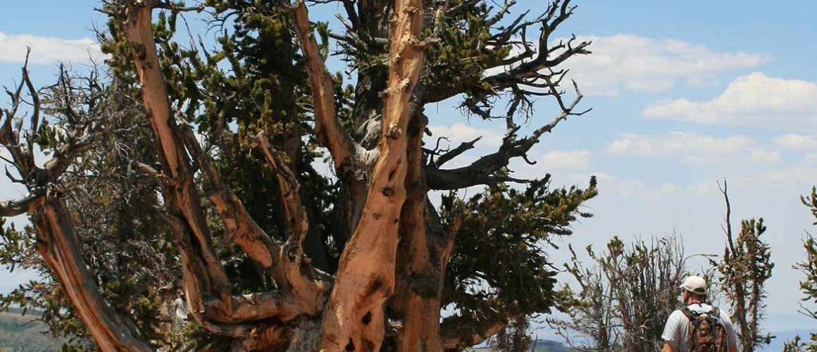
Bristlecone Pine Trail
An easy half-mile trail that’s great for families. You can see Zion National Park in the distance from an observation deck as you mingle among a grove of bristlecone pines. Trailhead is located on Hwy. U-14, at approximately mile marker 17.
Cascade Falls Trail
This trail provides spectacular views of Zion National Park and overlooks the Markagunt Plateau where it ends at the cascading falls from an underground lava tube out of Navajo Lake. This is where the Virgin River begins! Trailhead: Take the Navajo Lake FS Road #30053 then take first left onto FS Road #30370. Follow to the junction with FS Road #30054. Turn right onto FS road #30054 and follow to dead end at Cascade Fall trailhead.
NOTE: The lava tube is closed to travel due to the low levels of oxygen and high water flows.
Vermillion Castle Trail
The trail works to a rim and overlooks the road. Rock formations are on the rim and are composed of conglomerates and sandstone. The trail climbs steeply through grotesque rock formations before working to a ridge spine, continuing up the spine below a massive red rock cliff, and crossing a side hill of pinyon/juniper until it comes out to a large flat rock platform looking directly into Vermillion Castle and across the canyon to Noah’s Ark. Distance is 0.7 miles.
Virgin River Rim Trail
32-mile moderate trail that’s good for hiking, mountain biking and horses. The trail has several access points so you can make the journey as long or as short as you like. There are access points from Navajo Lake ( U-14) from the Te-Ah Campground, as well as Cascade Falls and Strawberry Point trailheads.
For more information and additional trails visit www.fs.fed.us/r4/dixie.
Mountain Biking
There are thousands of miles of trails and roads in the Dixie National Forest. Many of these trails are accessible by mountain bike. Also, the roads that wind through the forest are ideal for cycling. For a list of trails, visit www.fs.fed.us/r4/dixie.
Fishing
There are 500 miles of fishing streams and 90 fishable lakes in the Dixie National Forest. Game fish include brook, rainbow, cutthroat, and brown trout. For a list of lakes, ponds, rivers, and streams in the forest, visit www.fs.fed.us/r4/dixie.
Winter Sports
Opportunities for winter sports such as cross-country skiing and snowmobiling are available in many areas. The Forest Service works with Utah State Parks and Recreation to maintain trails for skiing and snowmobiling near Cedar Breaks and Bryce Canyon. There are also over a thousand miles of timber roads that can be used for these sports. There’s also Brian Head Resort which offers downhill skiing, snowboarding and snow tubing.
Plan Your Trip
Distance from Cedar City
18 miles east of Cedar CityBrochure
Pick up a copy of the Dixie National Forest Travel Map at any of the National Forest Offices or visitor centers.Season/Operating hours
Open year-roundElevation
2,800 to 11,322 feetCamping
Features 26 developed campgrounds and five picnic sites, as well as several group camping and picnic areas available, which can be reserved by calling ahead. Many recreation opportunities are available near campgrounds such as hiking, biking, horseback riding, fishing, boating, and more. For a list of campgrounds visit www.fs.fed.us/r4/dixie. -
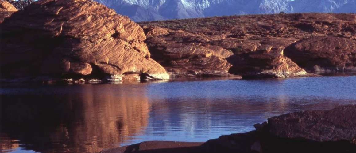
The Navajo Lake recreation area is located atop Cedar Mountain, approximately 25 miles east of Cedar City. This pristine lake was originally known to the Paiute Indians as “Pa-Cu-Ay,” meaning “Cloud Lake.” Early pioneer settlers gave it its present name after a confrontation took place near the lake between the settlers and some traveling members of the Navajo tribe.
Navajo Lake was formed when an ancient lava flow dammed the eastern side of the lake valley. Resting on a layer of limestone, the lake soon developed underground drainage through sink holes. Some of the water drains towards the Pacific Ocean via Cascade Falls and the Virgin River (the river that formed Zion Canyon). The balance runs east beneath the lava rocks coming out at the Duck Creek spring and sinking again to feed numerous springs that form the Sevier River (one of the few rivers in North American that flows north). The man made dike that stretches across the lake helps to maintain a constant water level. Boating, swimming and fishing are the most popular activities at Navajo Lake in the summer, and snowmobiling, ice fishing and snowshoeing are fun in the winter. There is a rustic lodge located at the west edge of the lake and reservations can be made by calling (702) 646-4197.
Lava Beds
Ancient lava beds surround the pristine Navajo Lake and Duck Creek areas. This geologically recent lava flow represents the last of the extensive volcanism on Cedar Mountain. Geologists believe that some of this lava rock is not more than 2,000 years old. Much of the lava did not come from a central volcano but welled up from cracks and fissures in the earth’s surface. There is a profile of a cinder cone that can be seen on the north end of the Navajo Lake and Hwy U-14 junction. One of the more interesting features of the lava beds is Mammoth Cave. This tunnel or lava tube was formed by cooling lava and water. The cave is about ¼ mile long and is safe to explore if proper care is taken. Mammoth Cave is located about a ¼ mile off the Mammoth Creek Rd. There are signs that direct travelers to the site.
Cascade Falls
Distance is a one mile, round-trip hike that leads you to a beautiful waterfall that is the outlet of Navajo Lake. See several varieties of plant life and incredible views of the Zion/Kolob Terrace.
Virgin River Rim Trail
Distance is a 32 mile moderate trail that’s good for hiking, mountain biking and horses. The trail has several access points so you can make the journey as long or as short as you like. There are access points from Navajo Lake from the Te-Ah Campground, as well as Cascade Falls and Strawberry Point trailheads.
Mountain Biking Navajo Loop
A nice, winding 12-mile loop around the lake that’s great for novices with just a few climbs.
OHV Use
There are several trails around Mammoth Cave for ATV and snowmobile use. Trail users are strongly advised to purchase a trail map from the Dixie National Forest Service Offices located in Cedar City or at the visitor center in Duck Creek (summer only).
Plan Your Trip
Distance Cedar City
26 miles from Cedar City along Hwy 14 to Navajo Lake RoadVisitor Center
Open mi- June through mid-September, the Duck Creek visitor center is the closest visitor center to Navajo Lake and is located along Hwy 14 near the Duck Creek Campground. (435) 682-2432Season Operating Hours
Generally late May to NovemberElevation
Surface 9,042 feetCamping
Navajo Lake features three campgrounds managed through a concessionaire contract with the Dixie National Forest. Camping fees range from about $10 to $18 per night. Spruces and Navajo campgrounds are on a first-come, first-served basis, while Te-Ah Campground has 20 units that are available for advance reservation by calling (877) 444-6777.Additional Services
Navajo Lake Lodge
(702) 646-4197
www.navajolakelodge.com -
Panguitch Lake is located in south central Utah and sits at an elevation of 8,400 feet. The word “Panguitch” comes from the Paiute word which means “big fish.” The lake is in close proximity to several world-class attractions such as Bryce Canyon National Park, Grand Staircase Escalante National Monument, and Cedar Breaks National Monument. Also close by are the communities of Brian Head and Duck Creek Village, Utah.
The lake has approximately 10 miles of shoreline and is ideal for year-round fishing. In the summer, find excellent fishing for some of the largest rainbow trout in Utah. Boats are available for rent and there are plenty of activities to enjoy in the area, including mountain biking, ATV riding and horseback riding.
In winter, ice fishing is a popular sport and easily accessible from local lodges. You can also enjoy snowmobiling, cross-country skiing and snowshoeing. Panguitch Lake sits in the Dixie National Forest and is adjacent to Scenic Highway 143 between the towns of Panguitch and Brian Head, Utah. Brian Head is a short drive away and a great place for downhill skiing in the winter.
Mountain Biking Indian Hollow
A 12-mile, mostly downhill trail with nice scenery and wildlife viewing. Over 200 miles of mostly downhill, single-track trails are located in nearby Brian Head.
OHV
There are several trails around Panguitch Lake for ATV and snowmobile use. Trail users are strongly advised to purchase a trail map from the Dixie National Forest Service Offices located in Cedar City or at the visitor center in Duck Creek (summer only).
Plan Your Trip
Distance from Cedar City
54 miles southSeason/Operating Hours
Open year-roundElevation
8,400 feetCamping
Panguitch Lake features three campgrounds managed through a concessionaire contract with the Dixie National Forest. Camping fees range from about $10 to $18 per night for single units. Panguitch Lake South Campground is on a first-come, first-served basis, Panguitch Lake North and White Bridge campgrounds have a few units available for advance reservation by calling (877) 444-6777. -
With over 600 surface acres and eight miles of shoreline, Quail Creek boasts some of the warmest waters in the state during the summer. The vivid blue waters in contrast to the red rock landscapes of Southern Utah make Quail Lake a popular destination for fishing, water skiing, boating, camping and picnicking.
Quail Creek reservoir was completed in 1985 to provide irrigation and culinary water to the St. George area. Most of the water in the reservoir does not come from Quail Creek, but is diverted from the Virgin River and transported through a buried pipeline.
The maximum depth of Quail Creek can reach 120 feet, so it is cold enough to sustain the stocked rainbow trout, bullhead catfish, and crappie. Largemouth bass, which are also stocked, and bluegill thrive in the warmer, upper layers of the reservoir.
Junior Ranger Activities
Activities are aimed at children six to twelve years, but everyone is welcome to participate. Download your copy here or request one when you arrive at the park. Complete the activities and earn a badge and certificate. Download your Junior Ranger Booklet
Fishing
Quail Lake is considered one of Utah’s top fisheries for largemouth bass. Other species include rainbow trout, bluegill and crappie. You can also obtain a license and proclamation at most sporting goods stores or through the Utah Division of Wildlife Services website: www.wildlife.utah.gov
Plan Your Trip
Distance from Cedar City
49 miles south I-15 to Hwy 9Visitor Center
Quail Creek Reservoir State Park
472 N 5300 W
Hurricane, UT 84737
(435) 879-2378Season/Operating Hours
Open year-round
Summer – 6 a.m. to 10 p.m.
Winter – 7 a.m. to 9 p.m.Elevation
3,300 feetEntrance Fees
A $10 day-use permit includes use of boat ramps. $75 Annual Passes are available at the Quail Creek State Park Office.Camping
Facilities include 23 developed campsites, three of which are accessible to the disabled. Two large group pavilions and public restrooms. Cost is $15 per night per campsite. Reservations are accepted for individual campsites by calling (800) 322-3770.More info
Quail Creek State Park
(435) 879-2378
www.stateparks.utah.gov -
Vermillion-colored rock formations and stands of ponderosa pine greet you as you enter Red Canyon. While many visitors think they are already in Bryce Canyon National Park, Red Canyon is actually a part of the Dixie National Forest, which stretches from the Nevada border to Capitol Reef National Park.
Red Canyon is part of the Claron Formation, the same geologic formation that created Bryce Canyon and Cedar Breaks. Sixty million years ago, sedimentary deposits in an ancient lake created the formation: a combination of limestone, siltstone, shale, sandstone and conglomerate. Subsequent uplifting and faulting created massive blocks that streams later carved into the Paunsaugunt and Aquarius Plateaus. A few million more years of erosion exposed the Claron Formation atop the plateaus. The fantastic ridges and spires, called hoodoos, are the result of weathering along the vertical fractures within the sandstone beds of the Claron Formation. Variation in the color of Red Canyon is due to the different amounts of iron and manganese present in each layer of the prehistoric sediment.
Pink Ledges loop
Distance is a mile-long trail that takes you behind the visitor center to spectacular views of Red Canyon and the Sevier River valley.
Arches Trail
Distance is a .7-mile hike that starts at the bottom of Losee Canyon and reveals 15 different arches.
Mountain Biking
Red Canyon is considered to be one of the most scenic mountain biking areas in Utah. Besides the paved bike trail along Hwy U-12, there are 34 miles of single track bike trails to choose from. Check for trail info at the Red Canyon Visitor Center.
Casto Canyon
Moderate trail about 14 miles, there and back. Scenic route with historical elements.Thunder Mountain Trail
Moderately strenuous trail for 8 miles, can become a complete loop by hooking up with the Red Canyon Bicycle.Red Canyon Bicycle Trail
Distance is 5.5-mile paved trail that parallels Scenic Byway 12, allowing hikers and bicyclists to experience the sights and sounds of Red Canyon.OHV and Four Wheeling
OHV use is allowed on the Casto Canyon Trail. Beginning at the Casto Canyon trailhead, the trail takes you into a wonderful world of red hoodoos, sandstone cliffs of white, pink and even green colors. The spectacular red rock is evident along most of the Casto Canyon ride until you reach the forested areas of ponderosa pines where the colors change with every turn of the trail.
Plan Your Trip
Distance from Cedar City
78 miles east off Hwy U-12Visitor Center
The Red Canyon Visitor Center is located on Hwy U-12 about two miles from the Hwy U.S.-89 junction. The seasonal (Memorial Day to Labor Day) center has information on sightseeing, picnicking, and other recreational activities in the national forest.Season/Operating Hours
Open year-round for recreation opportunities.Elevation
7,200 to 8,000 feetCamping
Red Canyon features a 38-site campground. The campground has shower facilities, restrooms, some new fire rings and grills, and paved sidewalks in some areas to provide improved access for people with disabilities. ATV riding is not allowed in Red Canyon Campground. Campsites are on a first-come, first-served basis. Campground information (435) 676-8815. -
The sprawling 20,000-acre park, which rests mostly on Bureau of Land Management (BLM) land, rivals Utah’s two largest state parks — Wasatch Mountain and Antelope Island. Sand Hollow is already one of the most visited destinations in the Utah State Park system, with recreation opportunities for nearly every user from boaters to bikers, and OHV riders to equestrians.
A favorite destination for local off-highway vehicle (OHV) enthusiasts, Sand Mountain provides 15,000 acres of perfectly sculpted dunes. Contact the Sand Hollow Headquarters for information about OHV areas and regulations at (435) 680-0715. The red sand is an incredible backdrop for Sand Hollow reservoir. At nearly twice the size of nearby Quail Creek Reservoir, Sand Hollow offers boating and other water recreation in a spectacular setting.
OHV Use
Sand Mountain provides 15,000 acres of perfectly sculpted reddish colored dunes to play in. Utah State Parks OHV Rules and Laws apply. For details on rules and regulations visit www.stateparks.utah.gov/ohv
Fishing
In addition to the bass, bluegills are abundant and are easily caught, even by novice anglers. The reservoir is heavily used by water skiers and jet skis during the warmer months, so you may consider going early to avoid the traffic and the heat. Even during busy times, however, conflicts between anglers and other recreational users have been minimal. Utah fishing regulations apply.
Plan Your Trip
Distance from Cedar City
54 miles south via I-15 to Hwy U-9Visitor Center
Sand Hollow State Park
4405 West 3600 South
Hurricane, UT 84737
(435) 680-0715Season/Operating Hours
Open year-round. Park entrance gates closed from 10:00 p.m. to 6:00 a.m. Please plan accordingly. A $10 day-use permit covers use of watercraft launches and OHV use. $75 Annual Passes are available at the Sand Hollow State Park Office.Elevation
3,000 feetCamping
Facilities include 43 developed campsites, two of which are accessible to the disabled. Cost is $21 per night per campsite with hookups. Reservations are accepted for individual campsites by calling (800) 322-3770.More info
Sand Hollow Reservoir State Park
(435) 680-0715 -
Snow Canyon State Park is a 7,400-acre scenic park tucked amid lava flows and soaring sandstone cliffs in a strikingly colorful and fragile desert environment. Visitors marvel at majestic views and the subtle interplay of light, shadow, and color dancing across canyon walls.
Located in the 62,000-acre Red Cliffs Desert Reserve, established to protect the federally listed desert tortoise and its habitat, Snow Canyon offers opportunities for outdoor enthusiasts of all ages. Activities include hiking, nature studies, wildlife viewing, photography, and camping. There are more than 18 miles of hiking trails, a three-mile paved walking/biking trail, technical climbing and over five miles of equestrian trails.
Park Geology
Transported by wind more than 183 million years ago, tiny grains of quartzite sand covered much of what is now Utah. These sand dunes, up to 2,500 feet thick, eventually cemented into stone. Burnt orange to creamy white in color, Navajo sandstone, the predominant rock in the park, is what remains of the ancient desert sand sea. Over time, water cut and shaped the sandstone to form canyons. Approximately 2.5 million years ago, and as recently as 10,000 years ago, nearby cinder cones erupted causing lava to flow down these canyons, filling them with basalt. This redirected ancient waterways, eventually carving new canyons. Look up to see lava-capped ridges that were once canyon bottoms. Snow Canyon is home to a diversity of plant and wildlife species not found elsewhere in the state.Park History
Created in 1959, Snow Canyon has a long history of human use. Anasazi Indians inhabited the region from A.D. 200 to 1250, utilizing the canyon for hunting and gathering. Paiute Indians used the canyon from A.D. 1200 to the mid-1800s. Mormon pioneers discovered Snow Canyon in the 1850s while searching for lost cattle. The canyon has been the site of Hollywood films such as Butch Cassidy and the Sundance Kid, The Electric Horseman, and Jeremiah Johnson. Originally called Dixie State Park, it was later renamed for Lorenzo and Erastus Snow, prominent pioneering Utah leaders.Whiptail Trail
Distance is 6 miles. Easy. Level with some slopes. Accessible to physically challenged. Tucked along the canyon bottom, this sinuous paved trail is suitable for hiking, jogging, biking and rollerblading.
Johnson Trail
(Open November 15 to March 1 only.) Distance is 2 miles. Easy. Level with some rocky slopes and steps. Boasting the only riparian area in the park, this trail winds through lava flows and red rock to an arch spanning 200 feet.
Jenny’s Canyon
(Closed March 31 to June 1.) Distance one-half mile. Easy, bevel with few slopes and steps. Trail leads to a narrow, sculpted canyon.
Sand Dunes
Distance is one-half mile. Easy. Deep sand with some slopes. Trail leads to a large expanse of red sand that is an excellent play area for children of all ages.
West Canyon Road
Distance is 7 miles. Easy. Gravel and sand surface. Fairly level. Trail follows a maintenance road winding past washes and towering cliffs to the mouth of present-day Snow Canyon.
Pioneer Names
Distance is one-half mile. Easy. Fairly level with some steps and slopes. This crescent-shaped trail passes pioneer names, written in axle grease, dating back to 1883.
Hidden Pinyon
Distance is 1.5 miles. Moderate. Rocky slopes. Drop-offs. This self-guided nature trail introduces geological features and native plants of the park.
Three Ponds
Distance is 3.5 miles. Moderate. Some rocky slopes. Deep sand. Trail winds through sandy washes to the mouth of a 400-foot canyon. Potholes eroded in sandstone catch seasonal rain, giving the trail its name.
Petrified Dunes Trail
Distance is 1 mile. Moderate. Some steep slopes, uneven surfaces. This trail crosses massive sandstone outcrops where you may explore sand dunes frozen in time.
Butterfly Trail
Distance is 2 miles. Moderate. Some steep slopes, steps and uneven surfaces. Winding along the west side of Petrified Dunes, this trail leads to West Canyon Overlook and lava tubes.
White Rocks Trail/Lava Flow Overlook
Distance is 4 miles. Moderate. Some rocky slopes, uneven surfaces. Passing through lava flows, juniper stands and breathtaking views of West Canyon, this trail leads to a natural amphitheater set in white sandstone. You can also reach the amphitheater on a 1-mile trail located one-half mile north of State Route 18 junction.
Plan Your Trip
Distance from Cedar City
60 milesVisitor Center
Snow Canyon State Park
1002 Snow Canyon Drive
Ivins, UT 84738-6194
(435) 628-2255
(800) 322-3770 ReservationsSeason/Operating Hours
Open year-round. Day use entrance fees for the park are $5 per vehicle for up to 8 people; $2 per person beyond eight. Entrance fees are paid at either the north or south entrances. Rangers are on hand to answer questions and a park brochure is provided at the entrance.Elevation
3,150 feetSeason
Open all yearCamping
Facilities include a 35-unit campground, modern rest rooms, hot showers, electric hookups, sewage disposal station, and a covered group-use pavilion and overflow campground. Camping fees range $15 to $18 a site. Reservations are accepted at (800) 322-3770.More Info
Snow Canyon State Park
(435) 628-2255, www.stateparks.utah.gov -
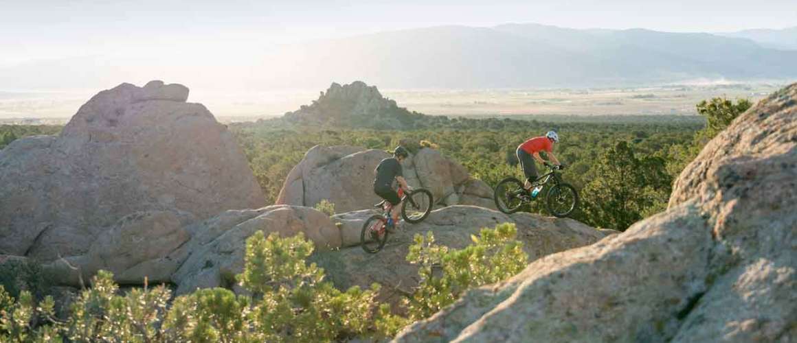
The rolling hills and volcanic rock formations of Three Peaks Recreation Area provide a fantastic location for outdoor recreation. Kids love to run, jump and crawl over the hunchbacked granite outcroppings expanding across the landscape. There are over 27 miles of mountain bike trails and 42 miles of OHV routes zigzag through Three Peaks’ 6,500 acres.
Three Peaks features several picnic areas with tables, fire rings and restroom facilities. There’s also a large parking area with a gated entrance for large groups and events. Two covered pavilions are available for group gatherings. These pavilions need to be reserved in advance; click here for the guidelines and reservation form.MOUNTAIN BIKING
A 19-mile mountain bike trail system runs through the complex and is often used for mountain bike races. The trailhead is located just as you come into the Three Peaks Complex near the County recreation area. There are restrooms and water located at the trailhead. | Three Peaks Trail System MapThree Peaks Loop
Moderate to difficult / Intermediate to advanced | 5.76 Miles | Spring & Fall | Loop| Map
This is an advanced ride with up-and-down riding equal to about 1,000 feet of climbing. There are some technical stunts such as Double-take Drop, and some very interesting granite slickrock on the south side. The granite is worth mentioning: This fine-grained pink granite presents a riding surface you won’t find elsewhere in Utah. The traction is good and enabling riders to make moves on the granite that can’t be done on sandstone.
Trailhead: Take exit 57 on I-15 and go west on 200 North / Highway 56 to Lund Highway. Take a right onto Lund Highway heading north. In approx. 5.4 miles turn left onto Midvalley Rd. heading west approx. 3.1 miles to a dirt parking lot where the trailhead is. Restroom and drinking water available at this trailhead.
Big Hole Loop
Moderate / Intermediate | 3.04 Miles| Spring & Fall | Loop| Map
The Big Hole Loop is an upper-intermediate ride with about 500 feet of climbing. The route follows a single track below a rock-quarry area on the far side of the mountain. A slightly shorter and easier upper route (used for racing) follows a double track above the quarry.
Trailhead: Take exit 57 on I-15 and go west on 200 North / Highway 56 to Lund Highway. Take a right onto Lund Highway heading north. In approx 5.4 miles turn left onto Midvalley Rd. heading west approx. 3.1 miles to a dirt parking lot where the trailhead is. Restroom and drinking water available at this trailhead.
Race Course Loop
Moderate / Intermediate | 3.79 Miles | Spring & Fall| Loop | Map
The race course trail has the best of everything for a mountain bike enthusiast. There are hill climbs, technical areas, sandy terrain and steep downhill portions on this trail, which is almost exclusively single track. This is an intermediate trail with technical portions, but beginners can manage nicely if they walk a couple of very short rocky side-tilted areas on the trail.
Trailhead: Take exit 57 on I-15 and go west on 200 North / Highway 56 to Lund Highway. Take a right onto Lund Highway heading north. In approx 5.4 miles turn left onto Midvalley Rd. heading west approx. 3.1 miles to a dirt parking lot where the trailhead is. Restroom and drinking water available at this trailhead.
Lost World
Moderate / Intermediate | 0.77 Miles | Spring & Fall | Point to Point | Map
This trail consists mainly of wider track riding and has very few technical areas. It is the only one of the five trails that is not a loop trail, but by connecting with the Practice Loop or the Race Course Loop can be turned into a longer loop trail.
Trailhead: Take exit 57 on I-15 and go west on 200 North / Highway 56 to Lund Highway. Take a right onto Lund Highway heading north. In approx 5.4 miles turn left onto Midvalley Rd. heading west approx. 3.1 miles to a dirt parking lot where the trailhead is. Restroom and drinking water available at this trailhead.Practice Loop
Easy/ Beginner| 1.58 Miles | Spring & Fall | Loop | Map
This is a beginner trail that given the novice mountain bike rider a chance to practice all the necessary skills before heading out on longer, more technical trails. There are instructional signs along the trail to assist the rider in improving their skill set. Uphill, downhill and sand riding will be experienced on this trail.
Trailhead: Take exit 57 on I-15 and go west on 200 North / Highway 56 to Lund Highway. Take a right onto Lund Highway heading north. In approx 5.4 miles turn left onto Midvalley Rd. heading west approx. 3.1 miles to a dirt parking lot where the trailhead is. Restroom and drinking water available at this trailhead.
Plan Your Trip
Distance from Cedar City
10 miles west via Midvalley Rd.
Head north on Cedar City Main Street to Midvalley Rd, turn left (west), stay on Midvalley all the way to Three Peaks.Season/Operating Hours
Recreation trails and facilities are open year-round.Elevation
5,600 feetCamping and Picnics
There are 18 individual sites that feature a shaded picnic table, trash bin, and fire ring. A restroom facility is located in the campground with water. Overnight camping is only permitted in the designated campground area. There is a $10 per night camping fee.Large Group Campground
Located southwest of Midvalley Road, the large group campground was designed to host large group gatherings. Currently, there are 10 campsites including fire rings, picnic tables and tent pads, toilet facilities and a large parking area. There are currently no fees for use of this area and it is available on a first-come, first-served basis.Group Gatherings
Two covered pavilions available for group gatherings with fire pits, swing sets, water, and restroom facilities. Picnic tables are located in the small pavilion. These pavilions need to be reserved in advance and a fee is required. Details and reservation forms are available at www.ironcounty.net, go to “Outdoor Recreation” and follow the links. Reservations are only accepted for the current year. For information call (435) 586-5124.More Info
Bureau of Land Management
176 East DL Sargent Dr.
Cedar City, UT 84721
(435) 865-3000
www.blm.gov/ut -
The Yankee Meadow area is a little known gem that offers outstanding beauty and recreation. Your journey begins five miles from Parowan along Hwy 143. You’ll the see the Yankee Meadows turnoff next to a small water retention basin (a good fishing spot).
As you drive up the Yankee Meadows Road (locals often call it First Left Hand Canyon) you’ll first encounter the Five-Mile Picnic Area neatly tucked away along the Bowery Creek. The picnic spot is surrounded by the towering red rocks of Vermillion Castle dotted with juniper trees and scrub oak and maple. Five-Mile is open late May through September for public and community use. No overnight camping is allowed and no potable water is available. Use of the 17 picnic areas is on a first come-first served basis. However, there is one picnic site that is tailored for large groups, which can be scheduled for use through Parowan City.
As you continue along the route, the Vermillion Castle will unfold above you. The area was named for the bright red rock formations and gray stone conglomerate cliffs. There are several trails that lead to the top of the cliffs where one can see the “Noah’s Ark” and the “Grand Castle” formations. In the fall, the scrub oak and maple blaze red and orange making it an outstanding area for leaf peepers.
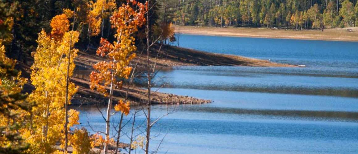
As you continue up to Yankee Meadows, the road meanders through lush fields of aspen and spruce. A Dixie National Forest campground is located on the east side of the road. The pavement ends at the campground and turns to a good gravel road continuing up to Yankee Meadows Reservoir. The scenery is fantastic at the lake with towering volcanic cliffs of Sydney Peaks rising in the distance. Summer and fall, trout fishing and non-motorized boating are the most popular activities. The reservoir shoreline is owned and administered by the Utah Division of Wildlife Resources while the water management is controlled by the Parowan Reservoir Company for irrigation purposes. Public access to the reservoir is open, but camping and grazing are restricted.
Facilities are limited at Yankee Meadows, so remember to take out what you bring in. No overnight camping is allowed at the lake and no potable water is available. Keep in mind that cell service is generally not available.
Vermillion Castle
Distance is 2 miles round trip. Moderate/strenuous. Trailhead is just past the Vermillion Picnic area. Trail switchbacks up through the red rock formations (referred to as hoodoos) to a large rock platform with scenic views into a deep canyon and the Noah’s Ark formation.
Henderson Hill
Distance is 2 miles round trip. Moderate. Trailhead is 3 miles up Yankee Meadow Road from Hwy 143. Trail crosses Bowery Creek and works its way up to a natural spring. Continue to the top of Henderson Hill for a scenic view. Great equestrian trail.
Mountain Biking
Yankee Meadows Loop: 13 miles round trip. Intermediate. All-weather road and double track. The Yankee Meadow Loop starts at Vermillion Castle picnic area. Ride the Yankee Meadow Road past the reservoir and follow the dirt track up to the junction of Second Left Hand Canyon Road. Ride down the road to Hwy 143 and back to Vermillion Castle. Very scenic trail. Over 200 miles of mostly downhill, single-track trails are located in nearby Brian Head. For more information, call (435) 677-2035.
OHV Use
There are several primary ATV routes around Yankee Meadows, including the Markagunt and the Second Left Hand trails. Trail users are strongly advised to purchase a trail map from the Dixie National Forest Service Offices located in Cedar City. For current OHV rules, regulations and safety classes, call
1-800-OHV-RIDE or www.stateparks.utah.govPlan Your Trip
Distance from Cedar City
32 miles northeast via I-15 to Scenic Byway U-143Brochure
Pick up a copy of the Dixie National Forest Travel Map at any of the National Forest Offices or local visitor centers.Visitor Center
Dixie National Forest District Office
1789 N. Wedgewood Ln.
Cedar City, UT 84720
(435) 865-3700Season/Operating Hours
Yankee Meadow Road and recreation facilities are open on a seasonal basis generally from early June through October.Elevation
8,685 feetCamping
Yankee Meadows Campground features 29 units with water, picnic tables, fire ring, two vault restrooms, and two double units with pull through driveways. Camping fees range from about $10 to $18 per night. Each unit is on a first-come, first-served basis, no reservations accepted. Campground is generally open early June through Labor Day weekend. ATVs are not allowed beyond the camp host site into the campground unless on a trailer (driven or pushed). ATVs may come in and out of the campground on a trailer only.Five-Mile large picnic site.
To reserve site call Parowan City (435) 477-3331.
Stay in the Loop
View this profile on InstagramVisit Cedar City • Brian Head | Utah (@visitcedarcity) • Instagram photos and videos